maandag 17 maart 2014

Kilme

KILME
 
A difficult place to find!
 
Beiroet is followed by ki-il-me-e in the list of Esarhaddon when he describes the place of the kingdom of Sidon in 676 BC. Some authors identify it either with al-Qalamoun, 10 km southwest of Tripoli, or with Kalmin, 4 km east-northeast of Batrun. Both suggestions disturb the order in the list of Esarhaddon. Although the names Qalamun and Kalmin show a similarity with Kilme, those suggestions had to be rejected according to the order of the Esarhaddon list. Especially concerning al-Qalamoun I have my doubts. The list of Esarhaddon is not holy. There can be a mistaken made by the scribe of Esarhaddon. El-Qalamoun is called by the Crusaders Kalamon(t) and that looks very close to Kilme.
 
Another approach is to look at what Strabo has to say. He mentions a mountain Klimax, which looks like Kilme also and that must be in the vicinity of Byblos. This mountain can be located between Byblos and the Adonis-river (Nahr Ibrahim) or between Palaebyblos and the Lycus-river (Nahr el Kelb). Mount Klimax has long been identified with the promontory Ras al-M’emeltayn closing the Bay of Gunye (Djounié) from the north. The arch of a Roman bridge can still be seen close to the Nahr al-M’emeltayn (Nahr el-Ma’amiltein) and the Passus Pagani (Pass of the countrymen) of the Crusaders has been located there. A creek to the northwest of the river’s mouth allows fishermen to moor their boats.
It is uncertain whether Klimax has to regarded as a purely Greek designation of the mountain or as an adaption of a local name. The second alternative is more likely and the town of Kilme should therefore be located in this area. It fits better in the list of Esarhaddon. It can not correspond to Palaebyblos which is mentioned likewise by Strabo (Geography XVI 2,1), also by Pliny (NH V 78), and appears as Balbyblos on the Peutinger Table and as Alcobile in the Bordeaux itinerary, where Byblos itself is missing.
Palaebyblos has to be situated at the Bay of Gunye, either at Gunye itself, called Iunia by William of Tyre or at Sarba, in the most protected area of the bay. The borough Sarba, located on a hill (alt.70m), has a monastery built in the ruins of a large Roman temple, which overlooked the bay and probably was the site of the Crusaders’ castle Sorbe as well.
 
Both places (Saba + Gunye) yielded monuments of the Roman period, but no further archaeological research was done in the densely populated area.
Kilme must be closer to the Ras al-M’emeltayn and might therefore be identified either with the village of Gazir, built on a hill (alt.380m) where it dominates the coastal road, or on the coastal road itself.
The latter location is preferable if Kalamos, mentioned by classical authors, is identical with Kilme. In fact, the name Kalamos suggests an area grown with reeds. Relating Antiochus III’s Syrian campaign in 218 BC, Polybius describes the military operations in the coastal area of Beirut, as follows:
“V 68,8-9:After this, he [Antiochus III] advanced by the promontory called Theouprosopon and reached Berytus, having occupied Botrys on his way and burnt Trieres and Calamus. From here he sent on Nicharchus and Theodotus with orders to occupy the difficult passes near the river Lycus, and after resting his army advanced himself and encamped near the river Damuras, his admiral Diognetus coasting along parallel to him.”
 
The text of Polybius thus locates Trieres, Calamus, and the Nahr al-Kelb between Batrun and Beirut. This confirmed by the Antonini Placentini Itinerarium, which mentions Triari between Byblos and Berut.
As a consequence, both Trieres and Calamus have to situated between Byblos and the mouth of the Nahr al-Kelb. If Calamus is Kilme and corresponds to a site near Gazir, as suggested above, Trieres should be located on a coastal road and identified with Tabarga or Berga.
 
Although the evidence is not waterproof, it is quite probable that Kilme has been found. Lipinski needs another two pages to convince us, but the evidence stays incomplete.
There is increasing evidence, but not fully. Conclusion: we are not certain.
 
See: Itinerary Phoenicia. E.Lipinski. Leuven OLA 90  St.Phoen. XVIII. 2008. Slightly adapted and shortened.
 
ncfps


vrijdag 14 maart 2014

Beiroet

 
BI’RU
 
The seventh name of a town in the list of the Assyrian king Esarhaddon (676 BC) about the kingdom of Sidon is Bi-‘-ru-u. Most of the researchers think it is modern Beirut. Just a few scholars think, that it is a place in the vicinity of Sidon, like Krahmalkov does in his Phoenician and Punic Dictionary (OLA 90, St.Phoen.XV, Leuven 2000, p.96).
However, despite the spelling Bi-‘-ru-u, which does not mark the final –t, this city must be identified with Beirut, the city of the “wells”, because Esarhaddon marches from the south to the north and Beirut is after Qartimme the following town: Bi‘ru.
Beirut existed already long before Esarhaddon. In the 3rd millennium BC the town was in the texts of Ebla mentioned as Ba’urtu and in the 14th century BC the town was also known as Biruta.
It is doubtful whether Beirut appears as B-i-r-t under Nos. 19 and 109 of the great topographical list of Tuthmosis III. Instead, the city is certainly attested in the epoch of the Amarna letters and of the Ugarit archives, both syllabic and alphabetic. We even have the name of a king or prince at that time: Ammunira. It is also mentioned at that time in Papyrus Anastasi I.20.8, which dates from the late Nineteenth Dynasty, i.e. from the end of the 13th century BC.
Roger Saidah explored from that time the so-called Kharji tombs in caves in the vicinity of what was the Byblos building in Beirut (Berytus XLI, AUB 1993/4: Beirut in the bronze Age).
 
Beirut was a Phoenician city in the first millennium BC, though it is not mentioned either in Phoenician inscriptions (except in a coin legend) or in the Old Testament. The context forbids its identification with Be’eroth (Josh.9.17), with Berothai (II Sam.8.8) and with Berothah (Ez.47.16).  The coin legend says lb’r[t] (Hill LIV) and lbyrt (Hill LIII).
 
We know the exact location and size of the walled city in the Bronze and Iron Ages. The city had the shape of an arc facing the sea and its total intramural area surmounted only two hectares, but it was protected by an impressive and well preserved defence system with walls 7 metres high.  
In the time of Esarhaddon Beirut was a small unimportant town, where there was water and food, but it had massive defensive walls. The city had obviously lost its former importance after several destructions between the 10th and the mid 8th century BC. Archaeologists even date a level of apparent abandonment to 750-700 BC, but an almost complete storehouse and a casemate wall could be dated to c. the mid-7th century BC.
We are not blessed with many findings out of this period, but there are two main exceptions. First: it was a major storehouse with many Phoenician storage jars and local red-slip as well as imported Cyprot and Attic amphorae. Second: there is an inscription on an ostracon (TDB 91001) at the excavation site BEY 003, nr 95.120 (Badr). It says: lšmn = for oil. The writing is in a cursive way, which we see also appear in Ires Dagi, Motya and Dona Blanca. Exactly in this 7th century BC this way of writing is becoming popular. See: Palaeographic observations on a Phoenician inscribed ostracon from Beirut, Ph.C.Schmitz (RSF XXX, 2. 2002).
 
In the Persian period (with growing Greek influence) the city was called: Laodike of Phoenicia. There was even a cemetery for dogs.
In the 4th century BC, Ps.Scylax mentions its harbour ‘open to the north’, thus indicating the site of the ancient city, which was not located on the Ras Bayrut, at the western extremity of the triangular promontory, but to the south of the modern harbour. The site was excavated in 1993-1996 and it was possible to establish the exact location and size of the walled city (240 by 120 metres) in the Bronze and the Iron Ages. In the area immediately adjacent to the north-west, a large quantity of murex shells and a basin complex were uncovered, offering possible evidence of local purple-dye production.
In the Hellenistic period a habitation area with well-preserved dwellings of pier-and-rubble construction laid out in an orthogonal plan was developed west of the old Tell. In this time the city got the name: Laodike, mother of Canaan / metropolis in Canaan on coins and seals.
The glass-industry is getting ever more exploited in Beirut and traders from Beirut go overseas to the Greek Delos.
In Roman times the cult of the sun becomes more important. There is an altar for Kronos-Helios.
 
Literature:
- Syria 1971. Antiquités Syriennes. H.Seyrig.
- Regards sur Beyrouth. R.Mouterde.
- La Mediterranée des Phéniciens. Institut du monde Arabe. 2007-2008.
- Archeology in the Beirut Central District. C.G.Cumberpatch, Berytus XLII 1995-96. AUB.
- Städtewesen 2009. Beirut and Tell al-Burak. H. Sadr.
- Berytos XLVIII-XLIX 2004-2005. Archaeology of the Beirout Souks.
 

donderdag 13 maart 2014

Hildua + Qartimme

HILDUA + QARTIMME
 
We arrive at the fifth name in the list of the Assyrian king Esarhaddon (676 BC) of the towns of the kingdom of Sidon = hi-il-du-u-a. I mentioned the place earlier (oktober 2013) in relation with Qartimme in the contribution: MISSION IMPOSSIBLE. At that time I had more questions than solutions. Now I have found more facts. So a revision is possible and necessary because it will become clear that we are dealing here with a conglomerate of towns and necropolis at a short distance of each other.
 
Han al-Hulde.
Lipinski states in his book Itineraria : “Here is a general agreement in identifying Hi-il-du-u-a with the mutation Heldua of the Bordeaux Itinerary and with present-day Halde, known in earlier literature as Han al-Hulde, 12 km south of  Beirut and 17 km south of the ancient city limits. The XII Roman miles indicated by the Bordeaux Itinerary as the distance from Berut to Halde are thus correct, but the VIII miles given as the distance from Halde to Porphyreon should be emended into VIIII (IX!?), since the actual distance by the ancient road amounted to 14.5 km. The Han al-Hulde occupied the site of the ancient city, as shown by the remains of the Roman-Byzantine town uncovered in 1967-1975 near the highway from Beirut to Sidon. They comprise private houses and churches with pavements in mosaics, datable from the mid-5th through the 8th century AD. Close to this place, two other churches have been unearthed in 1959.”
 
Lipinski is right, that Han al-Hulde (south of Halde or Khaldé) is the Roman-Byzantine town, but what is lying underneath it? Was that Hildua from the 7th century BC, or just bare grounds? In any case, it is only sure, that Han al-Hulde is at the first place a Roman-Byzantine town out of the late Roman period, although there are some objects found out of the Persian and Hellenistic period.
Because in Han al-Hulde or in the vicinity are found graves and inscriptions:
RES 1916: inscription with ink on an amphora founded in 1897. Text: ‘d’g‘lt. Meaning:?
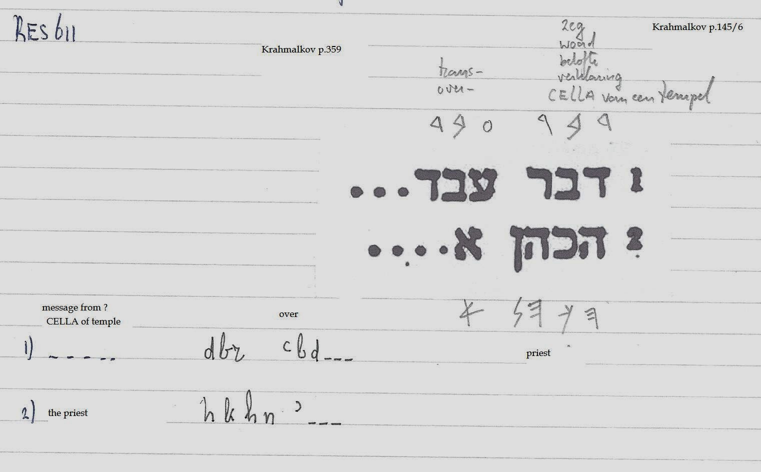
RES 611: inscription on a block of sandstone in the necropolis along the road from Beirut to Sidon. Text: dbr ‘bd ---- , hkhn’ ------. Meaning: it has something to do with a priest. The last inscription is from the 2nd half of the 2nd century?
There is still no proof, that Han al-Hulde is also Hildua, because nothing out of the 7th century has been found. Only the name of (k)Halde shows a great similarity to the ancient name, which Esarhaddon in 676 BC used: hi-ul-du-u-a!
 
Kobbet Choueifat.
Lipinski continues: “More to the north, on the slopes of the hill of Qabbat aš-šwayfet, a large Phoenician cemetery was discovered in 1961-1962 with 422 registered tombs. The 178 tombs excavated then by R.Saidah can be dated from the 10th through the end of the 8th century BC. They certainly confirm the existence of an important Phoenician town, which must be the Hildua of Esarhaddon’s inscriptions.”
 
There can be no doubt that this was a Phoenician necropolis, but was it accompanied at that spot by the town of Hildua? That is not sure.
In this very old cemetery the buried objects were urns for the cremation with a bichrome painting and so-called Red Slip jars with a round mouth or a threefold mouth and also Egyptian scarabs. Pilgrim-bottles and beer-bottles are found especially in the oldest graves.
There is even found a small Phoenician inscription= gtty.  We don’t know what that word stands for. We only know gṭy as a personal name.
 
Maybe the name Hildua was used for both places:
Hildua-the-town = Khaldé / Han al Hulde  (no great cemetery found yet)(only from 5th century BC)
Hildua-the-necropolis = Aš-šwayfet  (no town found yet)(from the 7th century BC)
 
To make things much more complicated: E.Forrer proposed Bet-Supuri at ‘Ayin Sawfar in: “Die Provinzeinteilung des Assyrischen Reiches, Leipzig, 1920, p.65”. Is by the way Aš šwayfet the same as ‘Ayin Sawfar? If not, this location must much more in the interior.
 
Qartimme.
Somewhere close to Beirut we find the sixth town, which Esarhaddon mentioned in his list from 676 BC. The exact location has not been found so far. It can be at the mouth of the Wadi al Ghadir or at Gneh or Al Awrai?
Lipinski in Itineraria Phoenicia: “The next city is called Qar-ti-im-me, which means in Phoenician: City at the Sea, in Phoenician letters: qrt-ym. The Byzantine chronicler John Malalas, born in Antioch, mentions a small town Khartima, which he locates in Maritime Phoenicia, at the border of Tyrian and Sidonian territories, and considers as the birthplace of Elissa-Dido, the reputed founder of Carthage. The same tradition is recorded in a Ge’ez chronicle, which suggested to Ch. Clermont-Ganneau identifying this with the village of Hartum, near the source of the Nahr Abu al-Aswad (in the vicinity of Tyrus). The place name is the same as Esarhaddon’s Qartimme, but its location does not favour the identification of the two towns. At any rate, the name suggests a location at the sea, possible as a marina deserving an inland city. One may refer to the Elkardie of the crusaders, which seems to contain the element el-Qart-, and the present-day hamlet of al-Qarteḥ, near aš-šwayfet, between Halde and Beirut. Qartimme might have occupied a site near the mouth of the Nahr al-Gadir, northwest of aš-šwayfet, or, further to the north, the stretch of land, between the beaches of al-Gneh and al-Awza’i, where rich ‘villae urbanae’ from the 6th century AD have been discovered by M.Chébab.
 
Conclusion: We have two towns at the coast, which use a large cemetery in the interior.  Those towns are probable named hi-il-du-u-a and qar-ti-im-me in the 7th century BC, although there are some doubts, especially on the exact locations. The name of the cemetery also out of the 7th century BC is not known for sure, but the location is certain.
 
Literature:
ITINERARIA PHOENICIA.
- Edward Lipinski. Orientalia Lovaniensia Analecta nr 127. Studia Phoenicia XVIII. Uitgeverij Peeters en Departement Oosterse Studies. Leuven – Paris – Dudley, MA 2004.
- R.Saidah. Khan Khaldé. Dossiers de l’Archéologie 12 (1974) p.50-59.
- M.Chébab. Mosaïques du Liban (BMB 14-15, 1958-59.
- Nicolas Carayon. Les ports Phéniciens et Puniques. Strassbourg 2008.


vrijdag 7 maart 2014

Bron bij de zee

SPRING AT THE SEA
 
The next city mentioned in Esarhaddon’s list of towns in the kingdom Sidon (676 BC)
is In-im-me, which is an obvious transcription of Phoenician ‘n ym, “Spring at the sea”.
It is rightly identified on phonetic grounds with the large village of an-Ne’me, en-Na’ima,
Naamé or el-Na’ameh, 15 km south of Beirut. This site has in fact yielded a large quantity of pre-Roman antiquities.
 

The word ‘n = spring we find in the inscription CIS I 3 / KAI 14 (lines16/17), made by Eshmunazor II, king of Sidon:
W’nḥn ’š bnn bt l’šmn šd/r qdš ‘n ydll bhr = And it was we who built a temple for Eshmun, the holy prince?, at the spring of YDLL in the mountains.
See: Ch.R.Krahmalkov, Phoenician-Punic Dictionary (p.381), OLA 90, St.Phoen.XV, Leuven 2000.
 
Is there still a spring in this village???
 
ncfps

donderdag 6 maart 2014

The Valley

The Valley.
 
Finding the Phoenician town Gi-’ in the Lebanon.
The location of the next town in the list of Esarhaddon is pretty sure and easy to find.
The third city of Esarhaddon is called Gi-’. It must be the present-day al-Giyye between the Ras Nabi Younès and the Ras es Saadiyat. 16.5 km north of Sidon.  In reality it is some km further away. Its site and the nearby Nabe Younus are usually identified with Porphyreon, although the fourth-century Bordeaux Itinerary locates Parp(h)irion at eight Roman miles or 12 km from Sidon. Porphyreon is already mentioned by Ps.Scylax and Polybius, who agree in locating the city between Beirut and Sidon.
Ps.Scylax par.104 (87).
Polybius V.68.6.
 
The importance of the site in later years appeared when 6th century AD mosaics were discovered on its territory. That is c.1300 years later!
See: Dussaud (1868-1958). In 1895-1901 he made five journeys to the Lebanon and Syria. His findings came in his book Topographie historique de la Syrie, Paris 1927.
See also the article of  E.Honigmann (ZDPV47, 1924).
 
There can be no doubt about the location of Porphyreon, but the distance given by the Bordeaux Itinerary ought to be corrected from VIII to at least XI miles.
Ps.Scylax does not mention its harbour, but Polybius reports that a fleet was anchored near Porphyreon in 218 BC, what implies the presence of a harbour or anchorage. Besides the distance from Beiroet to al-Giyye in coastal sailing may be estimated at about 35 km, which implies that a stop at Porphyreon would respond to the nautical practice of that time.
The Neo-Assyrian spelling Gi-’ of the city name, compared with the present day name of al-Giyye suggests interpreting this toponym as the West-Semitic noun gy’ : VALLEY.
This ordinary name once again show to us, that the Phoenicians used very common names for geographical sites.
The Greek name would allude to the purple industry based on the molusses Purpura haemastoma and Murex brandaris, found in great quantities in this part of the Phoenician coast and yielding the deep crimson dye.
The Hebrew prophet Jonah was said to have landed on its shores when he was spat out of the giant fish described in the Old Testament, and a temple was built which stands until today. Many invaders passed through Porphyreon such as Tohomtmos the Egyptian who landed his soldiers on its natural seaport in order to fight the North. Alexander the Great relaxed on its shore preparing for the attack on Tyre. St Peter and St Paul also walked through Jieh several times.

Archaeology

The town houses some of Lebanon's finest archaeological ruins, some of them buried under modern buildings, others waiting to be dug up by excavators, and others having already been removed and placed in museums. Mosaics depicting the story of the Prophet Jonah and the giant fish in the Old Testament have been found in churches dug from underground over time[. Examples of these are the grand floor mosaics from the Byzantine Empire period which were so big that trucks were needed to transport them to museums as was the case with the fine collection owned by Walid Jumblatt, a local politician, which are on display at his Beiteddine museum. Jieh has recently been the scene of accidental excavations of a Byzantine era Christian church and surrounding tombs which had been buried underground for centuries. Nothing is being done to protect them at the moment due to political hearings on the matters of the people versus the government - sec. landlords rights to preserve historical artifacts found on said property with vialble direct ancestry value and or documentation. The people versus the government - sec. landlords rights to preserve historical artifacts found on said property which directly pertain to all local populous religious beliefs, practices, and or scriptures or text. All which fall under the world preservation of historical and archaeological acts of 1971.
 
See:
Wikipedia.
Ancient Records of Assyria, D.Luckenbill, nr 512, p.205. Prisma B, col. II + Prisma S, col. III. Chicago 1927.
Adjusted excerpt from Itinararia Phoenicia, E.Lipinski, Ola 127, Studia Phoenicia XVIII, Leuven, 2004, p.17+18.
 
ncfps

woensdag 5 maart 2014

SIKKU

SIKKU
 
In the Akkad language this place is for the first time mentioned and called: sik-ku-u. It was one of the places belonging to the kingdom of Sidon, that was annexed by Esarhaddon, the king of Assyria in 676/66 BC. Esarhaddon let us know, that those are cities where there was ‘fodder and water’.
The second city in the list of Esarhaddon is Sikku or šikku, a name that should be related to Hebrew skw/h, a lion’s den. This word is attested in Jer.25:38 = He left like a young lion his den …… and Psalm 10:9 = He lay an ambush in a hidden place, like a lion in his den ….
This interpretation suggests identifying S/šikku with Leontopolis of Ps.Skylax and of Strabo.
 
Sikku is even more difficult to find in nowadays Libanon. But we know, that it has to be  somewhere around Sidon, because of the order from south to north in the list of Esarhaddon. And we get some help from classical authors. Strabo enumerates the Tamyras River, the holy grave of Asclepius, and Leontopolis. The Tamyras River is the Nahr ad-Damur, while Eshmun’s sanctuary is at Bostan aš-šayḥ, on the Nahr al-Awwali. Leontopolis should thus be located between the Nahr al-Awwali and Sidon. Now, precisely in this area, about 2 km from the old centre of Sidon, at the northern extremity of the suburb of al-Baramiyé or El Bouramieh and near the Nahr al-Giyas. The Han Abu šaka seems to preserve the ancient place name. This (k)han is apparently also called Khan es Sakkiyeh.
 
However, 6,5 km north of the Nahr al-Awwali, the old road to Beirut crosses the Wadi as-Sekke, where there as a khan with a few houses. I am not certain, if it is the Ouadi de Zeini, or the Ouadi Halaya. Nevertheless this is a good alternative. H.Sadr identifies S/šikku in 1997 at Rmayla (c.8 km north of the center of Sidon). 
 
There is even a third possibility, because Plinius (V.78) says: Leontos oppiddum lies between Beirut and the Lycus river (Nahr el-Kelb), but this is too far to the north.
 
One can thus hesitate for the location of S/šikku between al-Baramiyé and a site near the khan at the Wadi as-Sekke. At those places no excavation has been done so far. We will have to wait for that. After that maybe a more decisive conclusion can be drawn.


Ornithopolis

HOUSE OF THE BIRDS
 
In 676 BC the Assyrian king Esarhaddon mentions sixteen cities of the territory of the kingdom Sidon. The first city mentioned is Bet-s.u-pu-ri. This name must correspond to Phoenician Bt-s.pr, because of the similitude of the place names. Probably this means “Town/house of the Birds” (Bet-S.ippor). The Phoenician word “bird” was most likely pronounced like Hebrew. In the plural form the word is attested (s.prym) on a Neo-Punic ostracon from al-Qusbat in Libya.
Where do we find Bt-s.pr? The site of ’Ayn Sawfar, 21 km southeast of Beirut, is proposed. The list of places by Esarhaddon follows a south to north pattern. That makes the location of ’Ayn Sawfer too far to the north.
Now, Bt-s.pr has rightly located at Tell al-Buraq, 8 km southwest of Sidon, at the sea near Aadoussyé, near the Nahr al-‘Adasšiya. Its alternative localization at ‘Adlun, 18 km north of Tyre is at least less probable, since this area was given by Esarhaddon to the king of Tyre.
Later classical authors (Ps.Skylax, Strabo, Pliny) call the town: Ornithopolis, Ornithon polis or Ornithokome, which fits perfectly with the Phoenician meaning.
 
See: Ancient Records of Assyria, D.Luckenbill, nr 512, p.205. Prisma B, col. II + Prisma S, col. III. Chicago 1927.
Excerpt from Itinararia Phoenicia, E.Lipinski, Ola 127, Studia Phoenicia XVIII, Leuven, 2004, p.17+18.
 
TELL AL-BURAQ
 
The Phoenicians called it probably Bt-s.pr = house of the bird, although Adlun in the south and ’Ayn Sawfar are other possibilities. Al-Buraq is somewhat north of Sarafand located. It had no harbour and no cemetery. It was rather a stronghold and administrative city serving both a defensive and a storage function. We find now an overwhelming number of storage and food processing vessels. The town was surrounded by a so-called pier-and-rubble wall. This same way of building we find in f.i. Huelva, Castro de Dona Blanca, Carthage and Motya.
 
See: Phönizisches und Punisches Städtewesen, S.Helas + D.Marzoli, Rome 2007.
Beirut and Tell el-Burak, New evidence on Phoenician Town Planning and Architecture in the Homeland, Hélène Sadr.


ncfps