Posts tonen met het label algerije. Alle posts tonen

vrijdag 23 januari 2015

DE WILDE KUST

LITUS IMPORTUOSUM

Sallustius (1st cent.BC) called this coast of Algeria from Rachgoun to the mouth of the Oued Moulouya in this way (inhospitable/coast with no harbour).  However, Teissier says he found a Phoenician village in Sidi Samegram (Rev.Afr.1927, p.258). I can’t find this place on any chart now. G.Vuillemot searched along this coast in the places at Honein, Isle of Mokreum, Nemours and Port Say, but he found hardly anything, that looked like Phoenician or Punic. Perhaps there is an exception in Honein, but even that is not certain. These places have now other names: Honaïne (Honein) and Ghazaouet (Nemours). In antiquity the Oued Moulouya was called: MVLVCHA or MALVA FLVMEN. Honein got the Roman name: CYPSARIA PORTUS. Nemours was called AD FRATRES.
Now the coast stretches out over a distance of c.80 Km. It is therefore plausible that there was at least one port of call. Halfway Honein or Nemours would be the most acceptable locations for it.
Close to the mouth of the Oued Moulouya we find the Chafarinas islands. Those are difficult to enter for ships. They must have been used only in case of emergency. We arrived at last in Morocco now. Here ends the eminent work of Vuillemot and starts that of Montalban.

Honein: 
 Nemours:
ncfps

woensdag 21 januari 2015

Camerata

Camerata.
=======

On the way to the west after Mersa Bou Zedjar we encounter first the mouth of the Wadi Salado near the Plage Terga. It has good anchorage possibilities, but no Phoenician or Punic relics were found here. The next Wadi is called Ghazer, 35 km southwest of Cape Figalo. In this place G.Vuillemot found the handle of a Punic amphorae in an erosion slope which seems to indicate that a pre-Roman trade centre existed at this site (Reconnaissance, p.34). Until now no excavation has been done, but there are some ruins at the mouth of the Wadi Ghazer.
The attribution of coins with the Neo-Punic legend k m ’  to Camerata remains uncertain. See: Numismatique de l’ancienne Afrique, L.Müller, Copenhague 1860-1861 (NAA III p.124f, no 214). The Roman borough of Camerata occupied the site of a Moslem citadel erected at the mouth of the Wadi Ghazer. The evidence is meagre, but it is not impossible, that there was on this spot a pre-Roman trade centre.


ncfps

Rachgoun

RACHGOUN


The Phoenicians provided the North-African coast with dozens of strongholds and anchorage places. One of them was called Rašgun or Akra. Nowadays it is named aš-šakur or Argikule.
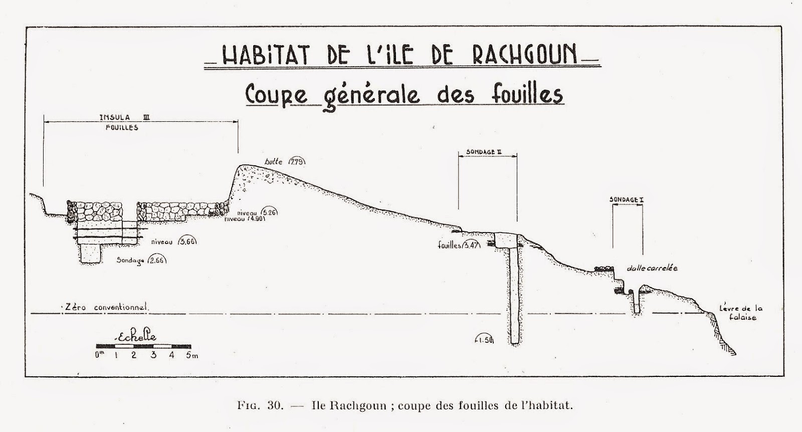
Ps.Scylax (111) mentions in the 4th century BC: “facing the river (=Sigi), the island of Akra, a large city and a harbour”.  This must be the island of Rašgun, distant 1700 metres from the shore in front of the river Tafna in western part of Algeria. The island rises 64 metres above the sea. The source of Ps.Scylax – the writer assembles information from others – only translates the first element of the toponym, since Rašgun appears as a corrupt form of Ra’š-šigan (Cape of Siga). Originally this was the name of the promontory of the Moorish Tower that protects the mouth of the Tafna river from the northeast. Phoenician-Punic remains contemporaneous of the insular settlement were found there and suggest an early occupation of the site by people living on the island. In the course of time the name of this cape (Akra) was extended to the island. The real Phoenician name of the island could have been ’y-r’š-sgn (=island of the majestic cape). This would be the same as Rusguniae (Cap Matifou in the middle of Algeria). The Phoenicians are using sometimes the same name for different places. The only site on the island that could be regarded as a harbour is a creek the water-plane of which measures 20 by 15 metres that is accessibly by a channel only 1.8 metre large and 0.6 metre deep. This recess on the seashore looks like an ancient Phoenician “cothon”. These small measures are not exceptional. In Motya and Toscanos we see comparable measures for the “cothon”. Only small boats could in this way reach the island. Greater ships must have been anchoring in the mouth of the river Tafna. Excavations in the “Necropolis of the lighthouse” have uncovered both cremation and inhumation burials with early Punic material, witnessing also connections with the Phoenician settlements on the Iberian Peninsula. There were 114 graves uncovered. Memorial stones (with inscriptions) are lacking. Jars with shoulder, funerary urns, dishes with a large rim, datable to the 7th century BC, were found mixed with handmade pottery, abundant in this burial context. On a scarab we find the hieroglyphs nb nfr sw (-shou, son of Râ) from the 7th century BC. The graves also yielded a number of weapons, like spearheads, amulets and silver jewellery from the 7th-6th century BC. Child burials were found as well: the small bodies were placed in natural cavities of the rock, the head always covered with a large stone. This habit has a similarity with some burials in Phoenicia where the diseased got a golden plate on the mouth. Soundings in the southern part of the island uncovered parts of dwellings, coarsely built in roughly broken rubble-stones bonded in mortar. Most walls were 0.50-0.55 metre thick and the preserved height hardly exceeded 0.50 metre. It was not possible to establish the plan of an entire house, but a disposition of rooms in file was observed, as well as the presence of windows and benches in stone. The use of baked bricks was limited for clay had to be brought from the mainland. No sanctuary or tophet was found on the island so far. For the water supply one was dependable on boats coming from the mainland, or the residents used the water from cisterns on the northern edge of the island. Like in the cemetery, the oldest material can be dated from the mid 7th century BC, while nothing seems to postdate the first part of the 5th century BC.  For some unknown reason at first sight, the settlement was then abandoned. Some occupation traces might remain in parts of the island which have not been investigated. When ps.Scylax refers to a large town it seems he got his information from an early 5th century BC source. However, fragments of Punic amphorae from the 5th century BC found on virgin soil, indicate that the use of the river-harbour at Siga on the river Tafna started in the final occupation period of the Rachgoun Island. The situation on the mainland must have felt save enough for the residents of the island in order to move to the river-harbour, which was called Takembrit in this period.


See: G.Vuillemot, Réconnaissances aux échelles puniques d’Oranie, Alger, 1962.

See : E.Lipinski, Itineraria Phoenicia, OLA 127, Studi Phoenicia XVIII, Leuven, 2004.

maandag 19 januari 2015

Mersa Bou Zedjar

MERSA BOU ZEDJAR

This place near Cape Figalo is a strange location full of question remarks. It starts with the Itinerario Antoninus (13,5): 26 miles to the east of Castra Puerum lies the town of Gilva or Gilua. That is about the location of Mersa Bou Zedjar. S.Gsell suggests to G.Vuillemot that he should search in Mersa Bou Zedjar. On a rather hostile coast for seamen this is the only possibility for a port of call, some 11 km west of Mersa Madakh. And indeed G.Vuillemot found some pre-Roman ruins. And more than that: also fragments of Punic and Italic amphorae of Campanian ware and Punic ovoid jars from at least the 3rd century BC. Besides that a Libyan inscription was found on a stele with a ritual scene at 1.5 km distance from the ancient settlement. Strange enough: there are no Roman vestiges. The pre-Roman settlement is located on the foreland of Sidi Moul Baḥar, a rock just to the north of Cape Figalo. In antiquity there was still a marsh around the ancient settlement, but in recent times it is drained now.
There is a lot of deliberation going on about the exact spelling of the name of the place. O.Cuntz thinks that we should read Silua instead of Gilua. That refers to:
Al-Bakri speaks of a town Aslan between Wahran (Oran) and Argikuk (Rashgoun).
On Punic coins we find the name ’sldn (2nd century BC) according to Mazar and Charrier. Lipinski and Krahmalkov are coming with the name ’šlbn (Müller 3.67 coins) and Krahmalkov mentions that with Salviana on page 461.
If the routing Gilva -> Gilua -> Silua -> Aslan > sldn -> šlbn -> Salviana is correct, then we have here a Punic settlement with the name on coins and Punic pottery. But that is all there is. It is not very convincing. On the other side it is the only possible port of call on the rather hostile coast. There is still a question mark: why there could be a Latin name (Salviana) and no Roman vestiges on the place.


vrijdag 16 januari 2015

Les Andalouses


LES ANDALOUSES

It is a complete surprise to find next after the Portus Divini an almost fully equipped Phoenician/Punic/Berber settlement on a spot that is not so favourable at all. Why did the Phoenicians make or took over on this bay between the Cape Falcon and the Cape Lindless this settlement with no significant harbour. It is true: there are some little islands in front of it: Isle Plane and the isles Habibas. They were visited by the Phoenicians, because one has found Campanian pottery here from the 6th century BC. A large settlement however was developed on the coast on both sides of the mouth of the Oued Sidi Hamadi. The reason why maybe the favourable agricultural possibilities, that were already exploited by the indigenous population. The site of Les Andalouses is located at the fertile plain some 30 km to the west of Oran.
It was identified by Ps.Skylax (111) as Mes in the 4th century BC and in the Itinenario Antonius as Castra Puerorum, XVIII miles west of Portus Divini. If Mes is the same as Mής, then it could mean in Greek: to suck. Les Andalouses becomes: City of the sucking child? Castra Puerorum can be translated as Camp of the Children.

Necropoli.
------------
There are several cemeteries found. The necropolis of the east contains graves from the 4th-2nd century BC. Here we encounter different funeral rites and structures with dominant Iberian influences. To the west on the right side of the Oued Sidi Hamadi the tumuli are containing Punic findings from the 6th century BC.

Settlement.
-------------
Between these two cemeteries lies the Punic town of about 3 hectares in surface. It has a rectangular plan. The houses are built on stretched stones of tuff mingled with earth. The use of windows was known. The population is for a part indigenous with a strong Punic influence. Maybe it is better to speak of Liby-Phoenicians?

Findings in Les Andalouses.
----------------------------------
- Carthagian wheel-made pottery
- Iberian pottery
- lamps
- jewelry
- ostrich eggshells
- suction bottles for children!
- steles, for instance: Masop, the son of Negasen
- shells of the murex
- purple dyeing factories
- Numidian, Mauretan, Hispano-Phoenician coinage
- Graffiti, for instance neopunic on Campanian B vessel and: g’, ’Ṣ, ḥ, Ṣzg‘n, gnk.
- Inscriptions: MTNT S W.TG.RS = gift of Wartagars (2nd cent.BC), URGHN (2nd/1st cent.BC), K?š (1st cent.BC), Masop.
- Coins: from Gadir: gdr, from Almunecar: ṢkṢ, Vermina, Bocchus.
- Paintings on pottery.
This list is far from complete. An incredible amount of material has been found by G.Vuillemot. See: Reconnaissances aux échelles punique d’Oranie, Autun 1965 and Vestiges puniques aux Andalouses, BSGAO 1951.


There are separated quarters of the settlement:

Mingeonnet.
---------------
Houses next to the sea. In the excavation here are 7 strata distinguishable.
1.Roman walls and Italic amphorae (2nd cent.BC)
2.Destroyed house
3.Punic walls of unpolished stones and pottery
4.Punic amphorae and fars
5.Ash-layer
6.beginning of the settlement (end 4th cent.BC)
7.virgin soil on 8.70 meters depth

Tassa.
-------
A late settlement (2nd-1st century BC).
We find here millstones, an oil press and mostly craft equipment and buildings.

Les Andalouses lived mostly on cattle-breeding (cows, horses, pigs, sheep, goats) and agriculture (grain and wine). For trade there were strong connections with the Iberian Peninsula.

The Romans came here only for a short period. They made a small settlement on the left bank of the Oued Sidi Hamadi. The settlements were abandoned by the end of the 1st cent. BC. One can only guess for what reason and where did they go? Why giving up such a fertile region?  Just a castle remains here: Castrum Puerorum. We don’t know the Phoenician/Punic name for this location, but there is a big chance it has to do something with children.


ncfps

donderdag 15 januari 2015

PORTUS DIVINI


PORTUS DIVINI

This is the gulf of Oran. From Arzew to Oran or Mers el Kebir it is a distance of 50-60 km (Itin.Ant.36 miles). That can be done with difficulty in a one-days-sailing. We can be short about Oran or Warhan (arab). Nothing pre-Roman has been found here. Only the name survived, if E.Lipinski is right in his explanation (Itineraria, p.411-412). Ps.Skylax mentions after Chalka (Quiza) the harbour Arylon (Αρύλων). This is not a Greek name, but Phoenician: ‘Ar-’ilon = Precinct of God. This noun is attested in a Phoenician inscription from Kition (Cyprus), where it designates the “precinct” of a temple. See: Fouilles de Kition III. Inscriptions phéniciennes, Nicosia 1977, C1, A6/7) by M.G.G.Amadasi/V.Karageorghis.

We find ‘Ar also in Transjordanian place names: ‘Ar-Moab and ‘Ar-Gilead. See: Numb 21, Deut 2, Is 15, Judg 12. The second element of Arylon is the singular ‘ilon = God. This toponym survived down to Roman times, when it was translated in Greek by Harbour of Gods (θεϖν λίμήν) in Strabo, Geography XVII 3,9; Ptol, Geo. IV 2,2 and in Latin: Portus Divini = Port of God. It is strange that we find here no pre-Roman relics, because the circumstances for a harbour/port of call by the Phoenicians are even better than it was at Portus Magnus.

dinsdag 13 januari 2015

Portus Magnus

Portus Magnus
===========


Sailing along the coast of the Dahra mountains from the east to the west the Phoenicians came to a large gulf where they have left many traces. It looks like they wanted to pass the Dahra coast as quickly as possible. The basis for their exploration of this gulf was without doubt the mouth of the river Chélif with the river-town Quiza. Anchorage is possible in certain periods of the year near the site of Sour Kelmitou (Wall of Chulimath), 7 km from the mouth of the river Chélif (Χυλωάθ). This place lies just below the ancient town of Quiza (Ptolemeus: Κουίςα). The Phoenicians focused however on several spots further away, especially on: Saint Leu or old Arzew (now: Azru), the mouth of the Macta and the little island(s) in front of modern Arzew.
The classical writers were aware of the good anchorage possibilities in this gulf, for they wrote: Pomponius Mela (I 29): …. As well as an harbour, who is because of its surface, called the Magnus. Plinius (NH V 19,2): Portus Magnus a spatium appellato. In the Periplus of Ps.Skylax the “sand”-island is followed immediately by a gulf with an island called Bartas (Βαρτάς). This must have been the Gulf of Arzew, protected by the Djebel Orouss from western winds.
Saint Leu or old Arzew became later the site of the Roman Portus Magnus, that cover over 30 hectares, but is 2 km distant from the sea. The rectilinear coast line in front of Saint Leu does not offer any shelter to ships, but the Phoenicians were accustomed to pull their ships on the beaches. It would have been no great problem for them, but of course they would look for shelter in the neighbourhood. West from modern Arzew lies the “ilot d’Arzew”, but that is too little to function as a harbour. In the 19th century AD another island was still visible in front of Saint Leu. A.Béard described the coast line from the Macta river to the warehouses of Arzew (Description nautique des côtes de l’Algérie, Paris, 1839, p.166). He sees s small flat island, a bare rock, very close to the beach, that was called the Island Tujisme. That name could be a Berber name: Tu-gisme. In Arabic gismi means ‘massive’, which reminds us of the name Portus Magnus. Tujisme could have served as a breakwater helping to protect the ships on the beach. This breakwater is now vanished, or it has become a part of the harbour-dams of modern Arzew.
The Phoenicians must have used also the mouth of the Macta, or the Sig, or the Oued Tinn. In ancient times it was called the Tasacora or Macsa. At that time this area must have been an inlet from the sea. G.Vuillemot has made here inquiries in the places Sbara, Fornaka and Port aux Poules, but there were no decisive results for a Phoenician or Punic presence.
The Roman town Arzew is located on a plateau 2 km away from the coast. The excavations have not yet reached the pre-Roman levels, but the traces and relics pointing undoubtedly to a Punic culture. In Saint Leu we find an open air sanctuary to the north of the town between the sea and the town. Here they have found the neo-Punic steles NP 78 + 79 and also Latin steles. Furthermore there are urns in holes in a ridge of tuff, which contained burned bones of mummified birds. NP 78 is dedicated to Baal Hammon and a Latin stele has the name of Saturnus. There must have been a sanctuary from the 1st century BC to the 1 st century AD, if not already earlier. Other findings are a fertility symbol, graves with late Campanian pottery (end 2nd century BC). Above the graves were standing steles with sometimes neo-Punic signs. One has found one Carthaginian coin (head of Ceres?), one monumental Punic inscription, an Iberian vase, a bas-relief of a man flanked by two horses.
The Romans left in old-Arzew mosaics, artworks and two houses with a peristyle (gallery of columns) behind. Os course there was also a forum and a temple, but that is all destroyed.


Neo-Punic Inscriptions:
N1 with the names b ‘ l b ‘ l (erratic for b ‘ l ḥ m n?) and b ‘ t ’ (=Beatus?) and m š g w ‘ n.
N2. ndr ’š nd[r] g p w m (or: gṭ’) yšm’’ ql’ (gpwm = name).
Those names in the inscriptions can be found in Names, Jongeling, p.156+158+162+188.
Vuillemot has found also an inscription in St.Leu. These are partly Punic letters, but the meaning is uncertain.


Nowadays:
The archaeological site of Portus Magnus (36 hectares) is stretched out as far as Bethioua and is threatened and for a part destroyed by an industrial area. Nowadays the Association for the protection of Roman ruins wants to protect the site and make it accessible for the public and create a museum on the spot. Beautiful plan, but will all of it be realised? In the past many stones from the site were used by the residents of Saint Leu and Bethioua for building activities on their own houses. Not long ago tourists were treated here in a bad way. But it is true: today there is more security and protection. However, so many is already lost.

Literature:
- Oranie, Vuillemot
- Ricerche Puniche, Bouchenaki
- Names in Neo-Punic, Jongeling
- Itineraria Phoenicia, Lipinski
- Ports, Carayon
- Maison à Peristyle, Rebuffat
- Le champ de stèles de Saint Leu, Gsell
- Sépultures punico-romaines, Vivant
- Vase ibérique du cimetière, Vincent
- La site de Saint Leu, Lassus
- Inscription punique de Saint Leu, Vuillemot
- Saturne Africain, Leglay


ncfps

woensdag 7 januari 2015

CARTENNAE


CARTENNAE


Location:
Nowadays Ténès is situated c.50 km west of Gouraya (Gunugu), the perfect distance for a day sailing by the Phoenicians. It is a small flat coast, where we find the old settlement (Al-Atika) next to a cape with the same name Ténès and the lighthouse of Sufism. Here we find Phoenician steles and pottery. There are also Phoenician graves on the west-coast next to the town with rings on the quayside on the rocks of Sidi Adasmas (Traghnia) for the landing of ships. On the cape the Phoenician/Punic necropolis has been found, but a large part of it is already fallen into the sea.

Name:
There are several explanations.
1. Carthenna is made of two words. Carth = town. Thenna = the name of the river in this region.
2. Carthennas is of Punic origin and consists of Qart = town and Tennes (Greek name). We are aware of a Sidonian king Tennes, but in reality he was known as Tabnit. His name means ‘model’ or ‘picture’ in Hebrew. Tabnit was translated by the Greeks to Thamn(e)i or Thammai(on) and finally Tennes. T b n y is also a king of Israel (1 Kings 16.21-22).  Our Sidonian king Tabnit (II) revolted to the Persians between 351/0-346/5 BC. His revolt failed in the end and he was beheaded. Sidon was taken and destroyed. Maybe fugitives from Sidon fled in that period all the way to Cartennae and called it the town of Tennes.
3.There could be a similarity in the name with Krṭn, Sbrtn, ṭp‘tn and if so, then the name is of Libyco-Berber origin.
Which one of this explanation is true, is impossible to say.

Legend:
There is an old legend of 3000 years ago, that says: “In the time of Moses, the people of Ténès were renowned magicians. The pharaoh of Egypt invited some of the best to come over and confront a thaumaturgic (making wonders) Israelite, who slew all the magicians on the banks of the Nile” (Shaw).

Tradition:
Pomponius Mela (c.44/43 AD) reports in: De Chorographia I 31: “Diesseits davon – denn Io; liegt fast in der Mitte der Küste – sind die Städte Kartinna (Ténès] and Arsinna sowie das Kastell Quiza, der Laterus-Golf (Arzew) und der Sarbale Fluss..... (Kai Brodersen in: Kreuzfahrt durch die Alte Welt).  Pomponius Mela calls the town Kartinna, another variation on Qart-tennes.

Roman colonization:
From c.150 BC Cartennae was already dominated by the Romans, although in name it was a part of the Numidian/Mauretanian kingdoms. Effective colonization begins between 43-25 BC together with Igilgili, Saldae, Rusazus, Rusguniae and Gunugu on the coast. In the interior: Tubusuctu, Aquae Calidae and Zucchabar. A Roman road is made from Cartennae to Castellum Tingitanum in the Zalacus mons. Augustus brought there a colony of veterans of the legion II Augusta. The feminine name of the place is Cartenna on the Wadi Allal and that was a Berber-town. The masculine name was Cartennas and that was former Phoenician port of call. Gaius Fulcinus Optatus defended successfully the town against attacks of the Baquates. The Greeks called this tribe: Bakoutai. Plinius mentions the tribe also.
Rogatus is a Donatist bishop. Vincentius is his Catholic successor. Bishop Rusticus is mentioned in 411 AD. St.Augustinus writes a letter, where the town also mentioned. After that the Vandals came and in that period a Roman woman buried all her jewelry in a hole in the ground and that was found intact in our days.

Conclusion:
Qart-tennes was a small port of call in Phoenician/Punic times. It was a part of the Mauretan/Numidian kingdoms and in Roman times it became a Roman colony. It was however never an important town, although her size reached the circumference of 700 x 400m. Almost all the Roman buildings are now gone.

Literature:
Salomon Reinach, Antiquités découvertes aux environs de Ténès – rapport sur une communication de M.Brunet, p.81. BCTH 1893.
Jacques Heurgon, Médaillon du trésor de Ténès, p.45-46. BCTH 1958.
F.Decret – M.Fantar, L’Afrique du Nord dans l’antiquité, Paris 1981.
G.Vuillemot, Réconnaissances aux échelles puniques d’Oranie, Autun, Musée Rolin, 1965.
Nicolas Carayon does not include the place in his catalog: “Les ports Phéniciens et Puniques, Geomorphologie et infrastructures, Strassbourg, 2008.”à but this time he seems to be wrong!


maandag 5 januari 2015

CARTILI


CARTILI


About 15 km west of Gouraya on the Corniche des Dahra the mouth of the wadi Damous would mark the site of the city Cartili in Roman times. The place Dupleix on the right bank of the river delivered some Roman relics. Nothing has been found here from the Phoenician/Punic period. About the name however a lot of speculations are going around:

1.Cartili has been regarded as a Phoenician foundation (Gsell, HAAN p.162-3), possibly named “City of God” = Qart-’ili. See: F.Vattioni (Per una ricerca sull’antroponima fenicio-punica, Studi Magrebini II, 1979, p.42-123).

2.Another explanation can be the relation with Q r t l y occurring in a neo-Punic inscription from Tunesia (NP 114: J.B.Chabot, Punica XVII,5 in Journal Asiatique 11th serie no.10, 1917-22). Q r tl y is the same for the Latin name Cartilius and the name Cartili for this location might have the same origin. Also the feminine form Cartilia is attested in North-Africa (CIL VIII 5682; 21022).

3.The modern name Damous could have had a very old past?! Damusi is the name of the king of Qarti-Hadašt on Cyprus in 673/2, named by Asarhaddon and Assurbanipal (as: Da-mu-u-si/su). This name is connected with Tammuz/Dumuzi, the equivalent of the Mesopotamian Adonis. In Phoenician the name D ‘ m ’ š = Damu has given.

The result of it all is that Nicolas Carayon does not include the place in his catalog: “Les ports Phéniciens et Puniques, Geomorphologie et infrastructures, Strassbourg, 2008). à Même si la situation maritime du site ménage des avantages portuaires naturels, les informations disponibles sont insuffisantes pour que l’on puisse intégrer la cite à ce catalogue.

If there was a Phoenician/Punic settlement then it must have been a very small provisional port of call. The distance to Gunugu in the east was not far away and therefore there was no necessity to make here a full equipped settlement despite the favourable harbour possibilities.
We lack here adequate further excavations.

Literature:
K.Jongeling, Personal names in Neo-Punic inscriptions, Grongingen, 1973
E.Lipinski, Itineraria Phoenicia, Leuven, OLA 127, 2004


vrijdag 2 januari 2015

GUNUGU


GUNUGU


This Phoenician settlement is located 33 km west of Cherchel in Algeria. It is the Qubba/Marabout of Sidi Brahim-el-Krouas next to Gouraya.


The Phoenician name of the settlement is not directly known, but an attempt to find it in Punic can be made by the following information:

The town is mentioned by

- Plinius (NH V, 20) > Gunugu is a colony of Augustus;

- CIV VIII 9071, 9423;

- Ptolemeus (IV 2,5) κανουίς ;

- It.Ant.(p.15) resp(tiblica) G(unugitanomm);

- Coin from Bocchus II of Mauretania with neo-Punic letters : g n g n.

The name Gunugu could be Libyco-Berber. We find g n w k n in the inscription CIS I 1443,3 and the corresponding K N K N in the inscription RIL 627. K.Jongeling gives a survey of all the Berber names ending on –kn op p.60-61 of his dissertation Personal names in neo-Punic inscriptions.


Excavations of the three necropolis have attested the existence of a pre-roman settlement of certainly the 3rd and 2nd century BC. The presence of Attic pottery proves however that the beginning of the settlement goes back at least to the 5th century BC. See: F.Villard (1959).

We find two necropolis on the eastern bay near Sidi Brahim and another on cape, which separates the western and eastern bay. In 1900 S.Gsell digs up the so-called “maison du charbonnier” = house of the charcoal-burner. It is a pit of 2 meters deep, without a staircase and a room nect to it for the deceased.


Shipping and trade.

-----------------------

Gunugu had overseas connections with Sicily and Spain and even with Lixus on the coast of Morocco and that is surprising for such a small settlement. In particular the connection with Villaricos is important. Here we see in both towns the ability of maintaining and painting egg-shells of the ostrich in almost the same way.

Maybe it has something to do with the pattern of colonisation by the Phoenicians. Briefly: In the beginning they took the northern route along Crete – Sicily – Sardinia to Spain.  In Spain they arrived already in the 9th-8th century BC and made there permanent colonies. On the way back they took the southern route along the North-African coast and made there only semi-permanent ports of call. When the Greeks however were threatening to cut off the lifeline to the homeland in the Lebanon, then it was necessary to reinforce the settlements halfway in Africa, Sicily and Sardinia in 6th-4th century BC. Most of the North-African Phoenician settlements as permanent towns begin in the 6th century, but Gunugu is an exception. The beginning here start at least a century earlier. I could elaborate much more about this, but here it is enough to understand, why the spread of the art of ostrich egg-shell painting went probably from Villaricos in Spain to Gunugu in North-Africa.


Ostrich egg-shells.

=============

Gunugu is a centre for the painting and decoration of ostrich egg-shells. The town joins a very old tradition, that started already before 3000 BC at Bahrein! From there it spread to Sumeria -> Syria –> Lebanon and by the Phoenicians all over the Mediterranean. Outstanding are the tombs of Djidjelli and Gouraya, with a rich series of the receptacle type with undecorated whole shells and three-quarter shells. The Gouraya examples are interesting for the iconographical repertoire painted on the three quarter shells. The geometrical and floral motifs, similar to those found at Carthage, do not exclude use of human and animal representations: a winged female figure, a male and an advancing ostrich enliven Phoenico-Punic iconographical influences with a popular stylistic language. In the three quarter shells the type of decoration is in yellow ochre and its style recall complicated designs: four metopes framed vertically by bands with geometrical motifs and horizontally by smooth, figured bands (See: Moscati p.456-463).

The geometric pattern and even signs/marks are almost the same, as we can see in Villaricos in Spain. The shells of Gunugu are broken due to earthquakes except one, says M.Astruc (1954). The signes on the shells of Villaricos are the oldest (6th century BC) according to Astruc. Thereafter comes Gunugu with her signs of the shells in the 5th century BC. But later Caubet in 1995 thinks that the shells may go back to the 7th or perhaps 8th century BC. See: A.Caubet: Documents puniques: les oeufs dáutruche de Gouraya, Actes de IIIe Congrès international des Etudes phéniciennes et puniques, Tunis, 1995 Vol I p.253-259. Moreover there is S.Moscati in the catalogue I Fenici (1988), who claims that the shells from Villaricos are from the 8th century BC. It is still uncertain, what the paintings on the shells mean. Is it religious or just an ornament? For some strange reason this habit of paintings dies out after the 2nd century BC.


Inscriptions.

=========

Gunugu is a remarkable settlement, because we find there also the incredible amount of at least 22 neo-Punic inscriptions. K.Jongeling traces down the personal names: g n s (N17),

g s m? (N18), z b y g y s/š (N9), y g y š w m (N12), m g w Ṣ (N11). See : Personal names in neo-Punic inscriptions, Groningen, 1974.

There has also been found an Etruscan inscription, engraved on a bronze disk, at Sidi Brahim. It comes from the 3rd century BC. You can read here (p)unicum Lartha. See: Y.Liebert, Une inscription étrusque d’Algérie, Revue des Etudes Latines 74 (1996) p.38-46.


Some history :

Carthage took over control in the 5th century BC.  In the 2nd – 1st century BC Gunugu became a part of the Mauretanian kingdom and from there it was a part of the Roman empire. So far nothing new. That happened to all the Phoenician settlements in North-Africa. But in the Roman period there is a difference, because we find hardly any Roman vestiges here.


Literature :

S.Gsell, Fouilles de Gouraya, HAAN II, p.161-162, Paris 1903.

F.Missonier, Fouilles dans la nécropole de Gouraya, Melanges de l’école francaise de Rome 50 (1933) p.87-119.

M.Astruc, Supplément aux fouilles de Gouraya, Libyca 2 (1954) p.9-48.

Mazard, Corpus Nummorum Numidiae Mauretaniarque, p.172-173, Paris 1955.

F.Villard, Vases attique du Ve siècle av.J.C.à Gouraya, Libyca 7 (1959) p.7-13.

Lepelley, les cités de l’Afrique romaine du Bas Empire, Paris, 1979-1981.

Leschi, Fouilles de la nécropole punique de Gouraya, BCTH 1932-1933, p.277-278.

ncfps

dinsdag 30 december 2014

IOL


IOL


The town Cherchel or Ašrašal lies immediately west of the “Corniche de Chenoua” on the coast of Algeria, about 88 km west of Algiers.

The Greeks named it in antiquity Iol and in Latin it got the name Iulia-Caesarea. The Phoenician name is reconstructed from the Greek Iol -> ’ y - ḥ l = isle of sand. Ps.Scylax’s reference to “the island of Psamathos” suggest the identification with the islet of Joinville as Sand-island. Is what I find in many sources really true? How is it then possible, that I find in the Phoenician and Punic Dictionary by Ch.R.Krahmalkov (OLA 90, Leuven) at page 183 the translation of Phoenician ḥ l = wealth, and not sand! In Hebrew ḥayil = wealth. On the other hand in Hebrew ḥôl = sand. What is right name for Iol?


There is no doubt, that this was a Phoenician trading-post. On the islet Joinville in front of Cherchel was the first occupation found. The excavated relics there are dated to the 5th century BC. Nevertheless it must be at least a century older, because the excavation in Cherchel itself has shown, that there are relics from the 6th century BC (pottery and lamps).

See: Approche d’un collection de poteriès puniques (musée de Cherchel), Akila Djellid, Africa Romana 14 (2000).


After the Carthaginian period Iol becomes the capital of the Mauretan kingdom under Bocchus II as a vassal king during the time of Caesar. The successor Juba II reigns this Roman protectorate from 25 BC – 23 AD and he changes the name Iol in Caesarea. Plinius (NH V,20) and Pomponius Mela (I,30) are mentioning the town. Pomp.mela I,30: ….. after that Iol at the sea, previously unknown, today famous, because it was the royal residence of Iuba and it is called now Caesarea.”  Juba II had probably the court poet Grinagoras of Mytilene. The king was married with Cleopatra Selene. Iol becomes a great Hellenistic centre. The seaport capital and its kingdom flourished during this period with most of the population being of Greek and Phoenician origin with a minority of Berbers. In the neighbourhood lies the royal mausoleum of Mauretania. It has 185,50 meter in circumference and has a diameter of 60,90 meters. It is now 32,40 meters in height and has a volume of 80.000 m3. Around it are standing 60 Ionic columns.

The cult of Baal Hamon is still attested in the 2nd-1st century BC by a Neo-Punic stele found near the Tenes Gate in the western part of the city. Steles from the Roman times, dedicated to Saturn, were uncovered in the same area, showing the continuity of the Punic cult in a sanctuary that certainly comprised a tophet.


In 40 AD follows the annexation by the Romans and Caesarea becomes the capital of the province Mauretania Caesaraea. Meanwhile an uprising by Aedemon is surpressed. Emperor Claudius (41-54 AD) gives it the status of colonia Aelia Tipasensis. A long aquaduct of 28 km delivers water from the Djebel Chenoun via Aquae Calidae and Sufasar. Caesarea becomes the birthplace of the Roman emperor Macrinus and the Greek grammarian Priscian. The town is now surrounded by 7 km of walls. It covers a surface of 370 ha.

In 238 AD we see the first Christian epitaph from the woman Rasena. Marciana is a Catholic saint. She was accused of vandalising a statue of the goddess Diana. After being tortured, Marciana was gored by a bull and mauled by a leopard in the amphitheatre at Caesarea.

The first known bishop was Fortunatus in the 4th century AD. In 372 Caesarea is burned down by the rebel Firmus. It is built up again. A new bishop comes forward between 372 and 380 AD: Clemens. Around 411 AD Caesarea is a Donatist centre under the bishop Emeritus, but he comes in confrontation with the Catholic bishop Deuterius and Emeritus is exiled. Apocorius is the last known bishop in 484 AD. He is sent away by the Vandal king Huneric.


INSCRIPTIONS

The most famous one is that of Micipsa (KAI 161) by the end of the 2nd century BC, which attests the presence of a sanctuary to this king Micipsa (148-118 BC). Height: 33 cm, Wide: 22 cm. It is on a marble stone and is now in safety in the Louvre museum in Paris. H.P.Roschinski (Die Mikiwsam Inschrift aus Cherchel) in Die Numider made a translation. The English version could be:

  1. Sanctuary for the “person”, the living, Mikiwsan, the king of the Massylians
  2. who brought justice in the lands, the lord of the kings, who brought well-being.
  3. For him was this memory made at the entrance of the chamber by Yazzam with his gift,
  4. son of Yuzgagasan, son of Bogud, son of Masinisan, the one placed to the gods,
  5. as a honourable memory for exactly the glory of his perfection (and) his mighty rank just like the “building”?
  6. and the priests, who were on all the heights, he assembled for him at that locate(on)
  7. of the building …..[….] with a flame? ..[….
  8. …………………………………[ and
  9. his chiefs he appointed in every settlement; he built in [every] estate [in
  10.  to him belonging densely settled areas a big “building” [ ……
  11. It was made by Ariš, son of Abdo, son (of ……


The grand-nephew (second cousin) Yazzam makes a statue for Micipsa and installs a cult for him in every settlement of the land. The real work on the inscription and/or statue is done by a person with a Punic name: Ariš.


K.Jongeling mentions the three Neo-Punic inscriptions of Iol in Names in Neo-Punic inscriptions, Groningen, 1984:

N1. NSI 56 (NP 130)

N2. KAI 161 (Micipsa)

N3 Dussaud BAC 1924 cxlvi


The last inscription is already translated in 1875 by Joseph Derenbourg in his contribution : “Sur une nouvelle inscription néopunique de Cherchel” (CRAI 19th year, no 3, p.259-266). The English version could be:

  1. A permanent memory to the good, intelligent woman. Rosh erected this monument, daughter
  2. of Abdešmun, son of Azrubaal, for her mother, as a sign of her grief, after was a stele
  3. for the living, husband of her, Azubaal [the younger] was gone… Hodbaal, daughter of Shaklan,
  4. her mother, in order to submit during 50 years on the isle of ḥashbar to the prescribed purification
  5. and she abstained from looking at the water of the reed (kana) and the isle of Dara, to keep herself blessed,
  6. as she also is compensated, the one that passed away on the age of 80 years.


It looks like someone is going to live as a hermit. J.Derenbourg links the isles of ḥashbar and Dara to one of the Canary isles and to the opposite river Darat. This could be doubtful.

See also: L’inscription néopunique, J.G. Février, Cherchel I RHR cxli p.19-25.


Further findings:

Head of marble, statue of Ganymedes, sfinx, head of a woman decorated by elephant, mosaic, milestones.


Literature:

Itineraria Phoenicia, E.Lipinski, Orientalia Lovaniensia Analecta 127, Leuven, 2004, p.405.

Princeton Encyclopedia of Classical Sites, R.Stillwell + W.L.MacDonald + M.H.MacAllister (ed), Princeton, 1976, p.413-414.

Die Numider, H.G.Horn + C.B.Rüger (ed), Köln, 1979 p.111-116, 227-242, 488-545.

Caesarea, N.Bensedik + S.Ferdi + P.Leveau, Cherchel, Alger, 1983.

Caesarea de Maurétanie, P.Leveau, Rome, 1984, p.9-13.

De Caesarea à Sherchel, N.Bensedik, Premiers resultats de la fouille du Forum, BAC = Bulletin Archéologique du Comité des Travaux Historiques et Scientifiques n.s.19B (1983/85) p.451-456.

Models of Urban Growth, the Cherchel Excavations 1977-1981, BAC n.s.19B (1983/85) p.457-468.

Vulnérability d’un capitale: Caesarea de Maurétanie, L’Afrique Romana V, Sassari 1988, p.253-269.

Rapport preliminaire sur la fouille du forum de Cherchel, Alger.

zaterdag 27 december 2014

TIPASA


TIPASA


Nowadays Tipaza lies c.63 km west of Algiers on the coast of Algeria. This distance can be done by the Phoenician ships, but it would have been hard labour. A port of call in the middle of this distance would be convenient. Near Zeralda at the mouth of the wadi Mazafran can have been a suitable solution.

The site of Tipaza offers an excellent anchorage for ancient coastal sailing and the Phoenician-Punic presence is attested there as early as the 6th century BC.

We are not really spoiled with Phoenician and Punic finds in the settlements views so far. But Tipasa is very different. Half a library seems to be written about Tipasa. Is that due to the by coincidence many successful excavations, or was there just a big difference in importance between Tipasa and all previous settlements to the east, with the exception of Hippo Regius?


The name:

ṭ p ‘t n (punic), tipasa (latin).

The Punic name occurs on coins (Müller 3.53). It could mean in Phoenician: passage.

The toponym seems to be Libyco-Berber, like all the Maghribine place names in Thi-, Ti-, Tha-, Ta-  and it was probably written: ṭ p ‘ t n, just like the Punic name of Tipasa.

The Latin name Tipasa is mentioned in Itin.Ant.15, Ammian.Marc.XXIX 5,17, Iul.Hon.699, Plinius V.220.

Teffesad (arab) means: badly damaged.


The Phoenician/Punic period.

There is evidence of the existence of a Phoenician/Punic settlement already in the 6th century BC. This settlement was situated west of the old harbor, as was proposed by M.Baradez (1960-62). Here we find a Punic wall around the deep (5-6m) harbor and relics on the nearby isles. In the harbor there is a great cave from the 6th century BC. Maybe an earthquake and/or a tsunami have played here a role. From the 4th and 3rd century BC there are two necropoli assignable with many Ionian and Attic material. One of them lies to the west on a cape and the other to the east of the settlement, also on a cape. No Punic document is available, but on the contrary many (neo-)punic memory-stones. On a distance of 1.5 km there is another small Phoenician/Punic settlement assignable from the 5th-2nd century BC.  Punic Tipasa had relations with Iberia, the Greek world and Italy. The later Roman town has covered most of the Punic relics, but they are still recognizable.


The Mauretania/Numidia period:

This period started at Tipasa by the end of the 3rd century BC under Syphax and Masinissa. In this time we see also the reigns of Bochus II and later Juba II. They are already vassal-kings of the Roman empire. Juba II is married to Cleopatra Selene (daughter of Cleopatra and Antonius). She calls herself Bassilissa. Maybe a nearby mausoleum could one assign to her. It is now falsely named after the Christian women. Pomponius Mela (I,30) mentions a mausoleum of the royal family in this area. By the end of this period Tipasa has to deal with the uprising of Tacfarinas. In 39 AD the son of Juba II is murdered by the emperor Caligula in Lyon and from that time Tipasa belonged to the Roman empire.


The Roman period:

Emperor Claudius gives the town the title Tipasa municipium iuris Latini in 46 BC  according to Plinius (NH V 2.20). Punic live survived however, because to the east of the town near the basilica St.Salsa at Koudiat Zarour J.Baradez found a little open air offering place with anepigraphic steles, altars for offering and vases with relics of nurned victimes. This sanctuary can be dated to 1st – 2nd century AD. Punic cellars to the east of the port came from the same period. Architectural aspects are still punic. A neo-Punic grave (1st century AD) with 150 objects for the offering (knife, ax, cleaver, scissors) were brought to the daylight. This must have been the grave of a priest for the offering (komer).

In 145-150 AD Tipasa becomes the Colonia Aelia Tipasensis. In the 2nd century AD the town had already an extensive circumference of 2.3 km in length. The walls are 1.60m wide and 7-9m high and have rectangular towers. Saturn is known from the late 2nd century AD and that implicates once again that there must have been a sanctuary of Baal Hammon.

1st half of the 3rd century AD: epitaph of Rasina secunda.

1st half of the 4th century AD: Schisma of the Donatists. During Julianus Apostatus (362-363) two Donatist bishops excercise terror with prosecutions. In 371 AD Salsa seems to have saved Tipasa from the rebel Firmus. There are more legends about Salsa. One of them says, that she was a young woman, who throws a snake idol into the sea. The outrageous crowd stoned her and she was casted into the sea as well. But her body comes back from the sea and she is buried in a chapel on a hill above the harbor. Are there more persons with the name Salsa. There has been found a sarcophagus of Fabia Salsa (also a woman), who reached the age of 63 years. The coins found under her cippus show that they come from the time of Constant the Great (begin 4th century AD). We are acquainted with an inscription from Corduba (4th century AD) with the text: praesis prov.Caes.ordini Tipasensium tabulam patronatus optulit (CIL II 2110).


The Vandal period.

In 430/429 AD Tipasa belonged to the Vandal empire. In 455 AD it was forced to pull down at least a part of the walls. By the end of the 5th century AD the Vandals under Huneric introduced the Arrianic religion. In 484 AD we hear of an episcopus Tipasitanus = Reparatus. The secretary of Cyrilla replaces the Catholic bishop Reparatus. The population flees over the sea to Spain. In 523 AD however the Vandal Hilderic allows the restoration of Catholicism.

In the 5th century AD the sarcophagus of Saint Salsa and the adjoining altar is decorated by Polentius.


The Byzantine period.

This period begins in 534 AD. The Byzantines restore the basilica and improve the defense of the town. After this period came the Arab invasion. Tipasa was completely destroyed.


The early excavations:

In 1892 M.l’Abbé Saint-Gérand in Tipasa. See: CRAI 36th year no.2 p.111-114. He finds a lot of Latin inscriptions mostly in the basilica of Alexander rector (=bishop). Some of them concerns about the building of the basilica.

M.Cintas begins here with scientific excavations, followed by M.Baradez around the harbor (1960-62) and M.Lancel (1964-1968). Cintas: Notes sur les fouilles récentes de Tipasa, CRAI 36th year. 1892. p.242. In the west a Christian necropolis was found in which a chapel with 9 graves of “justi priores” just before bishop Alexander.


Literature:

Impossible to mention all of it. Some important sources:

- Maisons à peristyle. Rebuffat 1969 : villa Fresco’s. c.150-160 AD.

- J.Baradez. Nouvelles fouilles de Tipasa: survivance du culte de Baal et de Tanit au Ier siècle de l’ère chrétienne. Libyca 5 (1957) p.221-276.

- S.Lancel – M.Bouchenaki, Tipasa de Maurétanie. Alger 1971.

P.Cintas. Fouilles puniques à Tipasa, Alger 1949, Revue Africaine 92 (1948) p.263-323.

Princeton Encyclopedia of Classical sites, princeton, 1976 p.925-926.

M.M.Morciano, Tipasa d’Algeria: un esempio di pianificazione antica in: L’Africa Romana X. Sassari 1994. p.403-418.